


7914987

jeanboulay
User
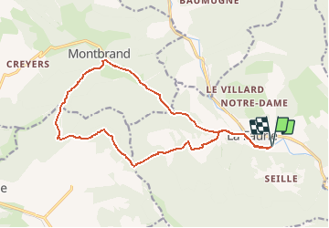

Length
17.4 km

Max alt
1228 m

Uphill gradient
533 m
Km-Effort
25 km

Min alt
827 m

Downhill gradient
533 m
Boucle
Yes
Creation date :
2020-07-31 12:53:12.955
Updated on :
2020-07-31 12:53:12.955

FREE GPS app for hiking
 SityTrail
IGN / Geographical institutes
SityTrail Plus
The world is yours!
About
Trail of 17.4 km to be discovered at Provence-Alpes-Côte d'Azur, Hautes-Alpes, La Faurie. This trail is proposed by jeanboulay.
Positioning
Country:
France
Region :
Provence-Alpes-Côte d'Azur
Department/Province :
Hautes-Alpes
Municipality :
La Faurie
Location:
Unknown
Start:(Dec)
Start:(UTM)
718172 ; 4938252 (31T) N.
Comments